A big difference a few hours makes........clouds have cleared and now sunshine across the #DC area. Still EXTREMELY muggy out there with temps back in the 80s! Just a few isolated showers this evening but no more heavy rain pic.twitter.com/9scFJcfavg
— Lauryn Ricketts (@laurynricketts) June 19, 2018
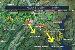
Heads up! Storms moving southeast through the area with very heavy rainfall. Storms will be around DC Metro/areas north until about 5PM. After 5PM storms are mainly south of DC. Mats/Os game should be ok! pic.twitter.com/sAgZTo1JLD
— Amelia Draper (@amelia_draper) June 19, 2018
Hot and humid today with early afternoon thunderstorms. Wake up with us! @nbcwashington pic.twitter.com/JRBNPNA1Rv
— Sheena Parveen (@SheenaParveen) June 19, 2018
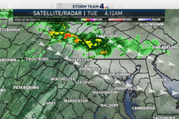
Some late night thunderstorms rolling across Pennsylvania have eyes on Northern Maryland over the next few hours. You will want to grab that umbrella no matter where in the DMV you live. Timing out your rain chances on NBCWashington. #Working4You pic.twitter.com/jie1YXEwrP
— Chuck Bell (@ChuckBell4) June 19, 2018


WASHINGTON — After strong thunderstorms moved through the area, scattered showers are expected to occur in the D.C. area for the rest of the evening.
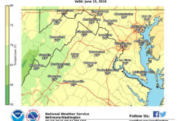
Earlier, the National Weather Service had issued a severe thunderstorm warning for D.C., parts of Virginia and Prince George’s County, Maryland.
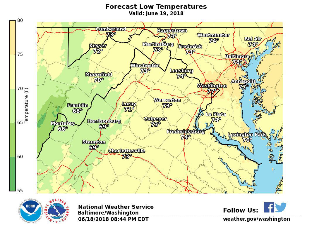
The rain cooled the area down to the 70s and 80s, when temperatures had been climbing into the high 90s earlier in the day.
With heat indexes near 100 degrees, D.C. activated its heat emergency plan during the morning and early afternoon on Tuesday.
The National Weather Service already recorded a heat index of 95 degrees by 9:30 a.m. When the temperature or heat index reaches that level, D.C.’s Department of Human Services and the Homeland Security and Emergency Management Agency will activate cooling centers for residents to seek relief.
Families seeking emergency shelter can call the DC Shelter Hotline at 202-399-7093 or 311 at any time day or night.
You can also find a list of cooling centers on D.C.’s Homeland Security and Emergency Management agency’s website.
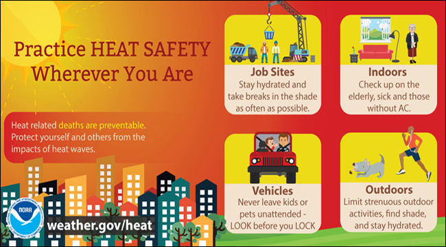
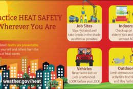
The temperatures and heat indexes on Tuesday could potentially be dangerous. Remember to be “heat smart” when working outdoors.
Here are some things you can do to help keep yourself safe:
- Limit strenuous outdoor activities
- Don’t leave kids or pets in a closed car
- Drink more water
- Drink less caffeine and alcohol
- Check on senior friends and neighbors
- Take frequent breaks
- Get medical help if you stop sweating
- Adults should take corrective action, and children should seek help, if they feel nauseous, their face feels like it’s burning or they have muscle cramps
- Make sure outdoor pets have ample shade and water
The Centers for Disease Control and Prevention has specific recommendations for the symptoms of heat exhaustion and the even-more-serious heat stroke.
Heat exhaustion
- Nausea or vomiting
- Cold, pale, clammy skin
- Heavy sweating
- Fainting
Under those circumstances, you should move to a cooler location, loosen your clothes, lie down, apply wet, cool cloth to as much of your body as possible and sip water. If you continue to vomit, seek medical help right away.
Heat stroke
- Body temperature above 103 degrees
- Hot, red, dry or moist skin
- Fast and strong pulse
- Possible unconsciousness
Find out where to keep cool in the D.C. area.
Monday saw temperatures get up to 94 degrees at Dulles International Airport, which tied a record for the date set back in 2006 and 2007.
Storm Team4 meteorologist Sheena Parveen said the weather pattern for the rest of the week will be fairly unsettled, which means there is a chance for rain almost every day and temperatures that are slightly above normal.
Temperatures should a bit cooler on Wednesday with highs in the mid to upper 80s with scattered showers and thunderstorms in the afternoon.
Thursday should see temperatures in the mid 80s with another isolated chance of showers and thunderstorms.
If you’re already looking ahead to the weekend, the chance of rain will continue throughout.
“Another weather system passes through across the weekend,” Parveen said. “So as of now, it looks like the highest chance for showers and thunderstorms will be Saturday.”
Forecast
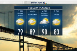
- Tuesday: Mostly cloudy with a high near 90 degrees and a chance for thunderstorms in the afternoon. Temperatures will dip to the low 70s on Tuesday night.
- Wednesday: Mostly cloudy with highs in the mid to upper 80s. Scattered showers and thunderstorms are possible in the afternoon.
- Thursday: Mostly cloudy with a high in the mid-80s and an isolated chance for rain.
- Friday: Mostly cloudy with highs in the mid-80s and a chance for showers in the afternoon
- Saturday: Mostly cloudy with highs in the mid to upper 80s and a chance for showers and thunderstorms.
- Sunday: Mostly cloudy with highs near 90 and a chance for isolated shower.