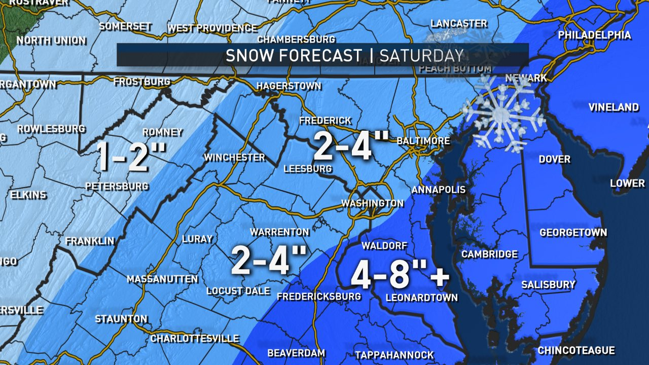
WASHINGTON — Snow has begun to fall in Southern Maryland, where 4 to 8 inches of snow are now expected by Saturday afternoon.
The National Weather Service has extended a Winter Storm Warning for Stafford and Spotsylvania counties including Fredericksburg in Virginia until 4 p.m. on Saturday.
In Maryland, Calvert, St. Mary’s and Charles counties are also under a Winter Storm Warning until 4 p.m.
Snow has already begun falling in parts of Southern Maryland and the Northern Neck area of Virginia. The snow will continue overnight with totals reaching 4 to 8 inches and in some cases, even more.
Two to 4 inches of snow is possible throughout the D.C. region however the heavy, wet snow is not expected to stick to roads in the immediate D.C. area, where a Winter Weather Advisory begins at midnight and continues through 4 p.m. Saturday.
The winter weather has prompted schools in Maryland and Virginia to cancel Saturday activities, including the ACT exams for several school districts, including Charles and Howard counties in Maryland and Alexandria City in Virginia.
Get the latest from the WTOP Traffic Center
Get the latest from the WTOP Weather Center
See the latest closings and cancellations
Quick Links:
Forecast:
Friday will be partly to mostly cloudy and chilly. Temperatures are expected to remain in the low to mid-40s. The evening hours will be cloudy and cold with temperatures in the low to mid-30s.
Light snow began to fall in St. Mary’s County on Friday afternoon and is expected to pick up Friday evening into the overnight hours, said Storm Team4 meteorologist Somara Theodore.
A Winter Storm Warning is in effect for Southern Maryland including Calvert, Charles and St. Mary’s counties. The warning also now includes Stafford and Spotsylvania as well as the city of Fredericksburg.
A Winter Weather Advisory has been issued for the I-95 corridor from midnight Saturday to 4 p.m.
Storm Team4 meteorologist Doug Kammerer said the coastal system is skimming our area and the latest models have pushed this stream of moisture deeper inland and west.
The immediate D.C. area will see a chance for snow showers beginning around 4 a.m. on Saturday. Snow should start tapering off by Saturday evening with the D.C. area seeing between 2 to 4 inches, Theodore said
Temperatures should be in the mid 30s during the day. But roads could refreeze Saturday night.
Throughout the day, expect heavy, wet snow to fall, said Storm Team4 meteorologist Amelia Draper.
But don’t expect much accumulation on treated roads. However on grassy surfaces or untreated pavement, Draper said.
Areas to the north and west of D.C. could see less snow. Higher snow totals are expected in the Southern Maryland peninsula and the Northern Neck area of Virginia.
The snow will end between 4 and 7 p.m. Saturday.
The winds will start to move in on Sunday, making for a very cold and blustery Sunday. The windchill may feel like it is in the teens at time.
Current weather:
Current weather:
Traffic:
WTOP Traffic will be monitoring all road conditions 24 hours a day. You can listen live on the 8s at 103.5 FM. For the most recent traffic report, visit WTOP’s Traffic page.
Commuting and travel:
WTOP’s Max Smith said that snow began to fall along I-95 just south of Fredericksburg, Virginia, a little before 10 p.m. on Friday. Traffic was steady, but even with a little open road, drivers were opting to stay below 60 mph.
The Virginia Department of Transportation began pre-treating roads in the D.C. suburbs on Thursday and continued on Friday.
If road temperatures drop enough, the snow could create slick driving conditions.
VDOT crews will head out to begin salting overnight. They won’t plow unless at least 2 inches of snow is on the pavement, said spokeswoman Ellen Kamilakis.
Brine pre-applied to roads in Northern Virginia should turn any snow into slush, she said.
She urged drivers to give VDOT salt trucks lots of room. They big, heavy trucks take longer to slow down and make wide turns. She said if drivers can hear the salting pinging off their windshield, they are following the truck too closely.
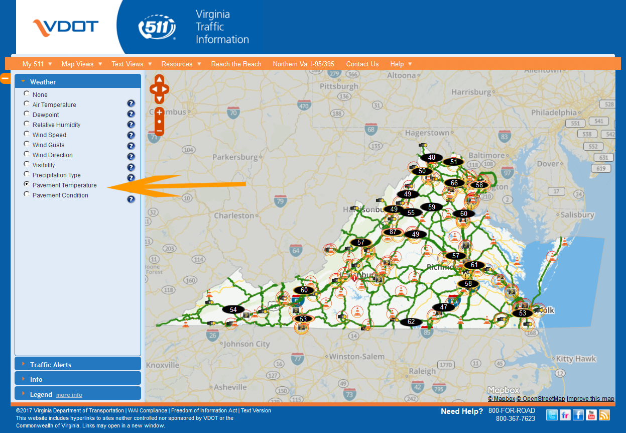
VDOT posts road temperatures online, which are a great tool for drivers to check before they hit the road.
Maryland State Highway Administration crews pre-treated roads on Friday and will return for work at midnight. Trucks will use rock salt to treat roads during the snowfall, said Greg Slater, Maryland State Highway administrator.
Contractors with additional trucks are on standby and can be called in to help with snow removal if needed, Slater said.
“We are geared up and ready to go,” Slater said.
His tip to drivers: Posted speed limits were designed for dry pavement. Give other vehicles plenty of space and slow down.
D.C. did not pre-treat roads but crews will begin treating the roads with salt about 2 a.m. All D.C. roads will be covered including residential streets, said Chris Shorter, director of the Department of Public Works.
“We assume we’ll move into a plowing operation by (Saturday) morning,” Shorter said.
Shorter asked that drivers give the plows room to work.
Track the plow:
Residents in D.C., Maryland and Virginia can track area snow plows’ progress:
How to check road temperatures:
VDOT posts road temperatures on its 511Virginia.org site. In the left navigation bar, choose the weather drop-down. Then click the button for pavement temperatures.
Listen live:
Listen live on WTOP.com, on the WTOP app or tune in to 103.5 FM.
WTOP’s Michelle Basch, Will Vitka and Max Smith contributed to this report.