WASHINGTON — Virginia’s Natural Bridge is used by about 2,000 drivers a day on Route 11, and after being loved by people from Thomas Jefferson to tourists today, it is stable enough to continue carrying traffic — for now.
A review for the Virginia Department of Transportation (VDOT) found that the bridge was still suitable for traffic, but that it should eventually be banned to protect the structure. VDOT is finalizing ways to reroute up to 5.5 miles of Route 11, and expects to present two or three preferred options this fall.
The preferred alternatives are expected to be revealed for public comment at a meeting next month, and are among several that have been considered by a number of groups in the area consulted by VDOT.
A draft recommendation could then be completed by the end of the year.
A review led by a Radford University geologist warned earlier this year that the vibrations and weight burdens of traffic and other human influences are speeding up the deterioration of the Natural Bridge.
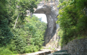
The 215-foot limestone arch north of Roanoke and west of Lynchburg was once owned by Thomas Jefferson, and has been a part of a Virginia state park in Rockbridge County since 2016.
For this review, the bridge was tested and examined through a series of vibration tests, high-tech radar, lidar and other scans.
The testing found voids in the rock at either ends of the arch, water moving through it and areas where rocks could fall onto park visitors below, according to a summary due to be presented this week to the Commonwealth Transportation Board, which would fund any major construction project to divert Route 11.
“The arch is currently suitable for vehicle traffic …[n]atural weathering and human activities will reduce that suitability over time,” according to the presentation.
To reduce the impact of continued traffic use, the state could make more efforts to keep water from getting into the rocks in the near term.
U.S. 11 over Natural Bridge runs parallel to Interstate 81 and serves as an alternative in the event of a crash on the highway. The alignment study is examining a 5.5-mile stretch of Route 11 from exit 175 on I-81 (Natural Bridge) to exit 180 (Fancy Hill). It has run over the Natural Bridge for decades, and any realignment would take years to complete.