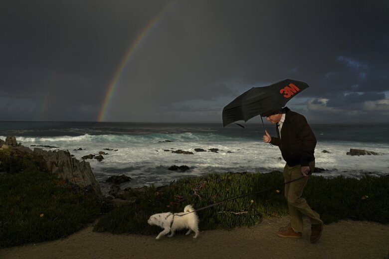
LOS ANGELES (AP) — Another potentially dangerous “Pineapple Express” storm was expected to hit California late Saturday, bringing the threat of flooding and mudslides over the next couple of days.
Californians spent Friday and Saturday preparing for what forecasters are saying could be the largest storm of the season, with the worst expected to hit Ventura and Santa Barbara counties on Sunday and Monday. Most of the state was under some sort of wind, surf or flood watch by Saturday afternoon.
The storm marks the second time this week the state will be pummeled by an atmospheric river, a long band of moisture that forms over the Pacific. The first arrived in the San Francisco Bay Area on Wednesday, delivering downpours and heavy snowfall that brought cable car service to a halt before moving south to Los Angeles and San Diego on Thursday.
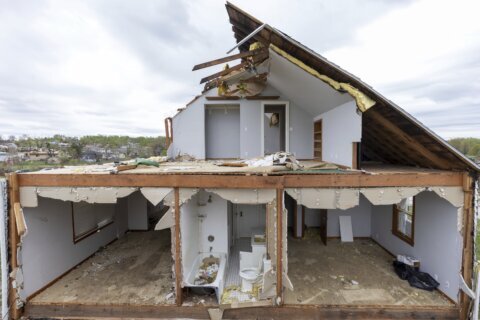
Last winter, California was battered by numerous drought-busting atmospheric rivers that unleashed extensive flooding, big waves that hammered shoreline communities and extraordinary snowfall that crushed buildings. More than 20 people died.
WHAT IS EXPECTED FROM THIS LATEST ‘PINEAPPLE EXPRESS’?
This “Pineapple Express” — called that because the atmospheric river’s plume of moisture stretches back across the Pacific to near Hawaii — was to arrive in Northern California on Saturday afternoon, according to the National Weather Service. Heavy rains and strong winds were expected through the night into Sunday.
The storm is forecast to move south down the Central Coast and hit the Los Angeles area with downpours, flash floods and high-elevation mountain snow beginning Sunday morning. It is expected to strike farther south, in Orange County and San Diego, on Monday. Heavy to moderate rain is expected to stay in Southern California until Tuesday.
The National Weather Service forecasts 3 to 6 inches (7.6 to 15.2 centimeters) of rainfall across Southern California’s coastal and valley areas, with 6 to 12 inches (15.2 to 30.5 centimeters) likely in the foothills and mountains. Rainfall rates are expected to be 1/2 to 1 inch (1.3 to 2.5 centimeters) per hour, with locally higher rates. Forecasters predict mudslides, debris flows and flooding to occur.
In the mountains with elevation above 7,000 feet (2,134 meters), 2 to 4 feet (0.61 to 1.2 meters) of snow will likely fall.
WHERE IS THE WORST EXPECTED TO HAPPEN?
Parts of Santa Barbara and Ventura counties will likely get hammered hardest by this storm, according to the National Weather Service. The south-facing slopes in the Transverse Ranges will be getting the heaviest rainfall, and flooding is likely to be exacerbated by already saturated soil from earlier winter storms.
Evacuation orders were issued for parts of Ventura County and some of Santa Barbara County, including along burn scars caused by wildfires, and in the city of Santa Barbara’s coastal areas. High winds will contribute to hazardous seas.
WILL THE WEATHER AFFECT WEEKEND SPORTS?
NASCAR moved The Clash at the Coliseum to Saturday night out of concerns for the impending inclement weather. Only heat races had been scheduled to be run Saturday at the Los Angeles Memorial Coliseum, but with a forecast calling for heavy rains and flooding to begin Sunday, NASCAR abruptly changed the schedule.
The Santa Anita racetrack in Arcadia, northeast of downtown Los Angeles, canceled its eight-race program that was scheduled for Sunday. The park also rescheduled a pair of graded stakes, the Grade III, $100,000 Las Virgenes and the Grade III, San Marcos, for next Saturday.
WHAT’S NEXT?
More damage is possible this year with El Nino, which is expected to bring additional storms to California caused by the temporary warming of parts of the Pacific that changes weather worldwide.
Rising sea levels from global warming are also causing the waves to be bigger off California’s coast, according to research. The coast is additionally seeing some of the highest tides of the season.
Copyright © 2024 The Associated Press. All rights reserved. This material may not be published, broadcast, written or redistributed.