A winter storm that threatened to bring icy conditions across the region didn’t materialize quite that way. While areas west of D.C. are seeing freezing rain, residents closer to the District are seeing only rain.
The threat of icy conditions prompted federal offices and schools across the D.C. area to change their schedules with most opening late, including the Smithsonian Institution’s National Zoo.
Today, our @NationalZoo and Smithsonian Castle will delay opening today until 10 a.m. and the @hirshhorn is closed due to a utility failure. All other Smithsonian museums in the Washington, D.C., area will open as scheduled on December 15, 2022. https://t.co/bLqdlI2HB3
— Smithsonian (@smithsonian) December 15, 2022
You can see the full list of closings and delays here.
Weather conditions also triggered the MARC commuter rail service to operate its R schedule on the Brunswick Line. MARC said all morning trains will run two hours later than scheduled in order to “ensure the safety of the train crews, station facilities staff, and passengers.”
- Listen to WTOP online and on the radio at 103.5 FM or 107.7 FM.
- Current traffic conditions
- Weather forecast
- Closings and Delays
- Sign up for WTOP alerts
- What should be in your emergency kit
An earlier Winter Weather Advisory issued until 1 p.m. for most of the D.C. area has been revised to only cover the area’s northern and far-western suburbs. Another advisory goes until this afternoon for northern Fauquier and Western Loudoun counties in Virginia and Carroll County in Maryland.
An Ice Storm Warning is set to last until 10 p.m. in Maryland’s Washington and Frederick counties.
Temperatures will continue to rise, with most of the D.C. area above freezing by 10 a.m. Ice is expected to build up on trees and power lines, mainly near the Blue Ridge.
Temperatures were close to freezing north and west of the Capital Beltway as of 7 a.m., with freezing rain and sleet being a problem over the northern and Western suburbs.
Rain was still pouring at a “steady pace” shortly after 7 a.m. in Hagerstown, Maryland, with temperatures teetering at 32 degrees at times, according to WTOP’s Nick Iannelli.
Temperature didn’t budge from my drive from Silver Spring to near Hagerstown. Heavy rain right at the freezing point the whole way. @WTOP pic.twitter.com/EJPT2Ma0SH
— Nick Iannelli (@NickWTOP) December 15, 2022
He reported visibility was just one of the challenges facing drivers on Interstate 70 and other area roadways.
“It’s a little uncomfortable at times because you do have those tailgaters and you do have the possibility for ice. So not traffic volume, but you might be a little uneasy at times when you’re looking at that temperature,” Iannelli said.
Temperatures will rise above freezing across most of the D.C. area by midmorning, bringing the icing threat to an end, but a few pockets of freezing rain may persist into the afternoon over the far-northern suburbs, according to Storm Team4 meteorologist Mike Stinneford.
Rain will taper off to drizzle and end tonight and no refreeze is forecast as temperatures will stay above freezing. Breezy and chilly weather is expected Friday and Saturday. Sunday will be cold, with high temperatures struggling to get out of the 30s.
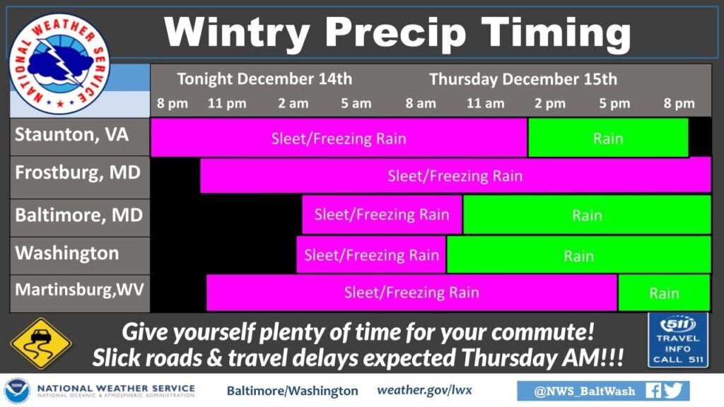
Precipitation will gradually change to all rain Thursday morning from east to west, but a few pockets of freezing rain may persist into the afternoon over the far northern suburbs.
By midmorning, however, these icy spots will have melted, but rain will continue through the evening commute, Storm Team4 meteorologist Chad Merrill said. This will happen between noon to 1 p.m. north and west of D.C.
“This means trees will get weighed down slightly by the ice; and secondary roads, parking lots and sidewalks will stay icy through early afternoon,” Merrill said.
Bridges and overpasses are first to freeze over, expect them to be especially slippery.
Drizzle will linger for a while Thursday night, but dry weather is expected by the time the morning rush gets underway Friday.
Temperatures will stay above freezing overnight into Friday across the D.C. area, but not enough to melt the ice accumulation where it will be thickest, along and north of Interstate 70 and along and west of Route 15.
The bottom line: Avoid the roads Thursday morning, if you’re able. If you must venture out before roads can be treated and temperatures warm in the afternoon, remember to slow down and leave plenty of stopping distance from the vehicle in front of you. Use extra caution on highways, overpasses and bridges.
Ellen Kamilakis, a spokeswoman with the Virginia Department of Transportation, told WTOP that this ice accumulation is most concerning.
“This is worse than snow,” Kamilakis said. “There is no strategy to driving on ice. This is dangerous.”
This warning extends to bus and rail commuters as Metro prepares for potential hazardous conditions around the region.
Navigating the weather
The storm is a great opportunity for a refresher on winter weather preparedness, even if early predictions aren’t bullish on snowfall this season. WTOP’s Chad Merrill has a helpful guide on tips — and common misconceptions — when navigating an ice storm, including:
- Beware of black ice: Ice is difficult to spot, especially in the dark. If you see shiny surfaces, assume it’s ice.
- Sights can be deceiving: Judging an ice storm by the degree of glazing on tree branches can lead to a false sense of security, since ice often gathers faster and thicker on flatter surfaces like roads and cars.
- Don’t forget about fog: Warm air moving over a cold ground makes fog more likely, which reduces visibility in turn. Remember to use your low beams.
Accumulation of ice on wires and branches means scattered power outages are also a possibility.
“Prepare for possible power outages. When venturing outside, watch your first few steps taken on steps, sidewalks, and driveways, which could be icy and slippery, increasing your risk of a fall and injury,” the weather service said.
For the latest road and traffic conditions, see WTOP’s traffic page or listen to updates every 10 minutes online or on the air at 103.5 FM. Download the free WTOP News app for Android and Apple phones to sign up for custom traffic and weather alerts.
Forecast
THURSDAY MORNING: A mix of sleet, freezing rain and rain becoming all rain by mid to late morning. Mainly rain east of Interstate 95. High temperatures in the upper 30s to mid 40s.
THURSDAY AFTERNOON: Rain, with pockets of freezing rain over the far northern suburbs. Heavy rain at times. High temperatures in the upper 30s to mid 40s.
THURSDAY NIGHT: Rain ending. Low temperatures in the mid 30s to lower 40s.
FRIDAY: Becoming partly sunny and breezy. High temperatures in the mid to upper 40s.
SATURDAY: Partly cloudy, breezy and cold. High temperatures in the low to mid 40s.
SUNDAY: Mostly sunny and chilly. High temperatures in the upper 30s to lower 40s.


