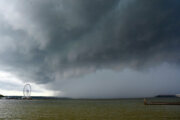
Flood warnings have expired for much of the D.C. area after a steady downpour has left the region much of the region drenched.
Flood warnings do remain in place for Frederick and Carroll counties in Maryland, as well as out west in Winchester, Virginia.
“As for the Washington, D.C. metro area, there is no warning currently in place but localized flooding is possible,” Storm Team4 meteorologist Somara Theodore said.
Standing water is still an issue for parts of the D.C. area with bouts of light rain expected to fall throughout the rest of Saturday and into Sunday morning.
Around one to two inches of rain fell in the D.C. area in the morning, causing flooding in some spots, especially in Fairfax, according to the National Weather Service.
An additional inch could fall with higher predicted rain totals north and west of D.C.
Much of the region saw about 1-2″ of rainfall, locally higher. As such, many of the rivers/creeks/small streams will see waters continue to rise. Thus, a number of Flood Warnings remain in effect. Additional rain showers are possible today, coupled with cool temps & breezy winds. pic.twitter.com/tIpWKNoDE2
— NWS Baltimore-Washington (@NWS_BaltWash) May 7, 2022
For the latest road and traffic conditions, see WTOP’s traffic page or listen to updates every 10 minutes online or on the air at 103.5 FM. WTOP’s traffic center is reporting on closed roads and crashes resulting from wet roads and downed power lines or trees Saturday morning.
Besides the rain, it will be cloudy and cool with highs in the upper 50s — that’s around 20 degrees below the average high temperature.
The storm system will finally exit by early Sunday, but the clouds will remain stubborn and northerly winds will keep it unseasonably cool.
At least two people in the District have been rescued from flooding by Fire and EMS officials, including a person in Montgomery County, Maryland, who was stranded on top of their car.
Water Rescue (~6a) Brighton Dam Rd near Bordley Dr, Brookeville, One (1) person stranded in/on vehicle. 1 person Rescued, not injured (just wet) NOTE: 1900blk Brighton Dam Rd CLOSED. Water level rising. @mcfrs BT740, BT725, A704, PE704, BC704 & SW710/710B boats others responded pic.twitter.com/3yNHIhBb0r
— Pete Piringer (@mcfrsPIO) May 7, 2022
Local jurisdictions are warning people not to drive through flood waters.
The new workweek will begin with a partly cloudy sky next Monday with highs in the upper 60s.
- Listen to WTOP online and on the radio at 103.5 FM or 107.7 FM.
- Current traffic conditions
- Weather forecast
- Closings and Delays
- Sign up for WTOP alerts
Forecast
SATURDAY: Soggy and cold with ongoing rain showers throughout the DMV today. Drivers should watch for standing water and washed out roadways to the north and west. Northerly winds of 20 to 30 mph with afternoon highs in the mid 50s.
SATURDAY NIGHT: 80% chance of rain, overcast with gusty wind Northeast at 10 to 20 mph. Temperatures will dip down as far as the 40s (Burbs) to near 50 (Downtown).
SUNDAY: Morning rain, then cloudy and drier through the afternoon. Northerly breeze and temperatures much cooler than average, with highs in the low to mid 50s.
MONDAY: Mostly sunny and warmer; highs mid 60s
TUESDAY: Mostly sunny and pleasant, with highs around the upper 60s to 70.
Current weather
Outages
WTOP’s Jessica Kronzer and Vivian Medithi contributed to this report.