The work week closes with another round of storms Friday, with rain that could be heavy at times. Here’s what you need to know.
Showers threatened the area through the night, and with already saturated ground and swollen streams and creeks from previous storms, a flash flood watch was issued Thursday evening that has since been canceled.
Most of the region will be dry overnight, but with high humidity, areas of fog will develop.
Another round of showers is expected Friday, and the weekend will have a chance of showers and storms on Saturday and on Sunday.
- Listen to WTOP online and on the radio at 103.5 FM or 107.7 FM.
- Current traffic conditions
- Weather forecast
- Closings and Delays
- Sign up for WTOP alerts
Water rescues
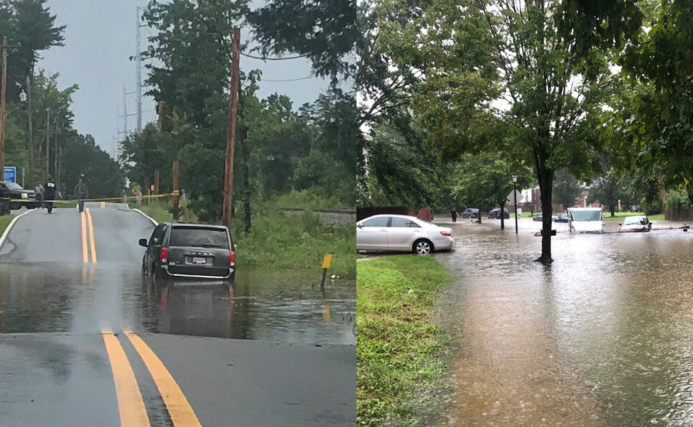
Prince George’s County Fire and Rescue spokeswoman Jennifer Donelan said Thursday that people had to be pulled from six vehicles that had gotten stuck in floodwaters.
“A couple of them it was standing water, where they could not move the car; in one, it was fast-moving water,” she said, adding that there were no injuries.
It’s not just the cars: “In one neighborhood, we saw floodwater that was reaching up to the doors of people’s homes,” Donelan said.
She added that she and the rescue crews are bracing themselves for further problems as well.
“It’s not raining here anymore, but we are watching the weather forecast, and we are very concerned about what’s coming,” Donelan said.
Her advice to drivers: “Please take heed to the warnings. You may think you can make it through the water, but that was not the case for at least six vehicles in the southern end of our county.”
Flooding in the 11900 blk of Birchview Dr. in Clinton. #PGFD crews assisted three occupants out of vehicles. pic.twitter.com/2PabCgheDD
— Prince George’s County Fire/EMS Department (@PGFDNews) August 13, 2020
The weather service said in a statement, “The Charles County 911 Center reported that one foot of water was flowing into homes along Bryans Road, and the Prince George’s 911 Center reported that Butler Branch was out of its banks and approaching homes on Birchview Drive.”
The warnings came as the wet weather from Tuesday and Wednesday continued through the D.C. area on Thursday, prompting early-morning warnings in Northern Virginia.
A morning of flood warnings
The National Weather Service issued its second flash flood warning of the morning at 8 a.m. Thursday for Prince William County.
The south central area of the county, including Dale City and Independent Hill, were included in the warning, as 3 inches of rain had already fallen in the area Thursday, with 1 to 2 inches in the forecast for the following hour. The warning expired at 11 a.m.
Earlier Thursday morning, just after 7 a.m., the service issued a warning for the west-central part of the county as storms had already produced 1 inch of rain in just the previous 20 minutes.
A forecast of 2 more inches of rain in the next hour prompted the flood warning, which the service said could be “life-threatening.”
That warning said residents of Linton Hall, Gainesville and Nokesville should be aware and turn around if they are driving and encounter standing water.
WTOP’s Neal Augenstein reported that in the 9 a.m. hour, a driver was rescued from the roof of his car in Prince William County after a 911 call.
The county’s fire and rescue squad arrived, took out a boat and brought the driver to safety.
WATER RESCUE in Prince William County: 911 call to Valley View Drive, for driver stranded on roof of vehicle. @PWCFireRescue took boat out, rescued driver from roof of car. He’s safe. Drove into standing water, near Valley View Park, got stranded. @WTOP @WTOPtraffic pic.twitter.com/r5sh6es7VB
— Neal Augenstein (@AugensteinWTOP) August 13, 2020
Instantaneous rainfall
Kyle Pallozzi, a meteorologist with the weather service in Sterling, Virginia, told WTOP the combination of this week’s stalled frontal boundary coming on the heels of Isaias, which made landfall in the U.S. on Aug. 4 before pushing up the East Coast, was a unique combination.
The stalled frontal boundary, which produces multiple days of rain, happens once or twice per year, but that weather event, coming just a week after a major storm, is not common.
He called the instantaneous rainfall rates of the last two days “pretty impressive.”
More downpours and storms are in the forecast later Friday, with the chance for some storms over the weekend as the air remains muggy.
Storm Team 4 meteorologist Chuck Bell said after Thursday, the day with the greatest rain chance will be Sunday.
Into next week, rain chances decrease as high pressure from Canada may take hold and push the tropical weather to the south.
Forecast
- Thursday night: Patchy fog late. Lows upper 60s to lower 70s
- Friday: Cloudy and humid. Scattered showers and storms. Highs in the low to mid-80s. Flooding possible.
- Saturday: Partly sunny and muggy. Chance of afternoon storms. High in the low to mid-80s.
Current conditions
WTOP’s Thomas Robertson contributed to this report.