WASHINGTON – Sorry snow lovers, Wednesday’s storm is not a perfect storm.
In fact, I have been putting off writing up a forecast all day due to the uncertainty of accumulation and timing for our next system: an Alberta clipper midday Wednesday.
I will say confidence in this write-up is higher than it was a few hours ago, Tuesday morning. But we are still going to have to watch how models develop and what track the system takes. We all know how the Jan. 6 system came tearing through our region during a morning commute, dropping 2 to 5 inches of snow on us as an unexpectedly heavy band of snow formed. So we are proceeding with this particular forecast using caution.
Tonight, temperatures will fall into the upper 20s to the lower 30s. We could even get a few hours of fair skies before clouds move back into the region ahead of our next system. An area of low pressure will come diving out of the northwest and through the Ohio Valley and track right into the Mid-Atlantic Wednesday. High pressure will sit to the north, feeding in a northeasterly flow that may keep some temperatures around the WTOP listening area from rising too quickly during the day.
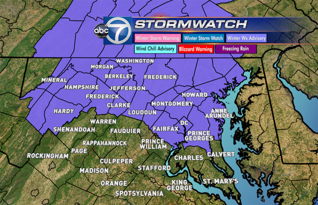
Winter Weather Advisory
A winter weather advisory has been issued for most of the listening area beginning at 6 a.m. and running through 6 p.m. Wednesday.
Timing
It looks like the morning commute should turn out okay. If your morning commute takes you past 9 a.m., then you will have to keep an eye to the sky, especially if you are west of D.C. as this system will move from the northwest to the south and east.
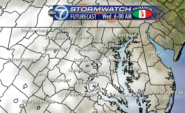
This however will leave a very tough forecast for schools as most of the precip should begin after 10 a.m. starting as snow north and west of D.C. (northern Loudoun, Frederick and Washington counties in Maryland, plus the eastern West Virginia panhandle and the Shenandoah Valley).
It should start as a mix of rain and wet snow flakes or just plain rain for the D.C. metro area and the suburbs depending on temps.
Road temperatures across the area are fairly warm thanks to temperatures hovering around the 50 degree mark both Monday and Tuesday (here is a look at Maryland Highway road temps). Therefore, it would take a lot of snow to overcome the warm surface temperatures to actually accumulate. But that is not to say it can’t happen (insert “meteorologist have the easier job” joke here).
If we have a heavy band set up (this will have to be determined and better analyzed as we get closer to midday Wednesday) then we could overcome those warm road temperatures and actually see snow stick. Again, this will be something we have to monitor.
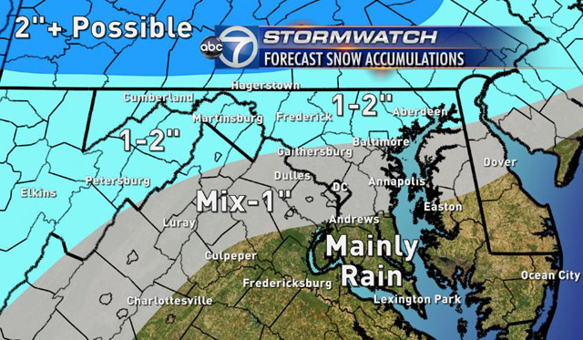
Totals
This is our best guess for snow totals as of Tuesday afternoon. Areas to the north and west could see 1 to 2 inches as those areas hang on to colder air for longer. Temperatures around D.C. should be above freezing Wednesday morning at the onset and drop through the afternoon as cooler air gets pulled into the system. This means an eventual changeover to snow for D.C. area.
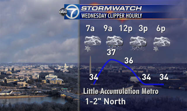
Again, this is mainly a daytime system which will bring precip to the region between 10 a.m. and 4 p.m. with perhaps some lingering snow showers during the evening commute. The evening commute could be a little more problematic than the morning commute as temperatures drop. However, if you are headed to Annapolis for the inauguration of the governor and lieutenant governor, then you may want to pack some cold weather and waterproof gear.
And as always, I wish I could give you a 100 percent guarantee on this forecast, believe you me, it would make my life much easier; however, there is still a good deal of uncertainty with this forecast.
This is the best bet we have so far. Again, if any significant changes come along, I will be sure to update you! So stay with WTOP for updates.
Follow @WTOP on Twitter and on Facebook.