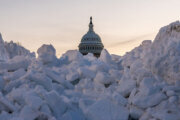
A mix of rain and snow flurries rolled into the D.C. area Sunday, but there was little to no snow accumulation for much of the region.
While forecasters initially warned that snow totals could range anywhere from a light coating in the District to up to 3 inches for northeastern Maryland, residents were ultimately left experiencing a “forecast bust.”
That’s according to WTOP Meteorologist Mike Stinneford, who said the fallout was the result of a change in overnight temperatures.
“When the precipitation came in, it’d be mainly in the form of snow, but then temperatures rose just above freezing as the front came in,” Stinneford said.
“Mainly, we just saw rain across the region with a little bit of sleet and snow, but temperatures stubbornly above freezing, so roadways are just wet.”
He added that there hasn’t been any travel issues so far in the region.
Sunday night is a different story, according to the National Weather Service.
With temperatures dropping well below freezing tonight into Monday morning, be wary of black ice because wet roads will freeze. It could be slick and slippery, especially on untreated, secondary and back roads.
Slow down and use caution. That includes walking, too.
Road and sidewalk conditions should improve later Monday morning as temperatures warm to above freezing, the NWS said.
Bundle up for Monday if you’re participating in any outdoor activities marking Martin Luther King Jr. Day, such as the District’s annual Peace Walk and Parade. Evans said wind chills will be in the 30s.
- Listen to WTOP online and on the radio at 103.5 FM or 107.7 FM.
- Current traffic conditions
- Weather forecast
- Closings and Delays
- Sign up for WTOP email alerts
- Get custom alerts with the WTOP app for Apple and Android phones
FORECAST
TONIGHT:
Mostly clear
Lows: 18-24
Wind Chills: 10s
Winds: West 5 mph
Clouds clear for the most part and light winds will allow temperatures to drop into the teens and 20s.
MLK JR. DAY:
Mostly sunny
Highs: 35-40
Wind Chill: 30s
Winds: West 10-20 mph
High temperatures will top out in the upper 30s with wind chills going from the teens in the morning to 30s during the afternoon. Dress warmly if you are heading to the annual MLK Peace Walk & Parade starting at 11 a.m. in southeast D.C.
TUESDAY: COLD ALERT
Sunny
Highs: 25-30
Wind Chill: 10s
Winds: Northwest 10-20 mph
The coldest day so far this winter is in store with wake-up wind chills near zero degrees. Afternoon highs stay below freezing in the upper 20s.
WEDNESDAY:
Sunny, breezy
Highs: 35-40
Winds: South 5-15 mph; Gusts: 20-25 mph
After a very cold start to the day, temperatures will rebound quickly with a return of south winds. Otherwise, a pleasant and sunny day is expected.
THURSDAY:
Partly cloudy
Highs: 40-45
Winds: West 5-10 mph
Pleasant day with partly cloud skies and seasonable temperatures.
CURRENT CONDITIONS
Get breaking news and daily headlines delivered to your email inbox by signing up here.
© 2026 WTOP. All Rights Reserved. This website is not intended for users located within the European Economic Area.