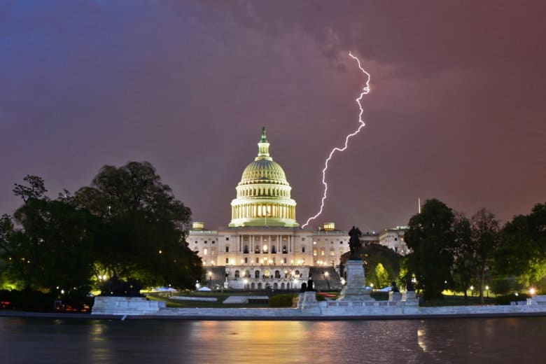
Severe weather in the D.C. region brings a tornado watch for much of the D.C. region.
- Listen to WTOP online and on the radio at 103.5 FM or 107.7 FM.
- Current traffic conditions
- Weather forecast
- Closings and Delays
- Sign up for WTOP alerts
What to expect
The National Weather Service has issued a tornado watch until 3 a.m. for much of the D.C. region, including Maryland and Virginia suburbs. A tornado watch means damaging winds may cause trees and branches to topple. Power outages are possible.
There will be a lull in t-storm activity for the next several hrs, but the severe weather threat has not ended! Thunderstorms, some with damaging winds, will cross the region overnight. A tornado is still possible. Make sure you can receive weather warnings after you go to bed. pic.twitter.com/mL8VhwnWBd
— NWS DC/Baltimore (@NWS_BaltWash) April 15, 2019
“If you spot a tornado, go at once into the basement or small central room in a sturdy structure,” the National Weather Service said.
There is a severe weather threat that started late Sunday afternoon through early Monday morning, with the window for the biggest risk until 4 a.m. Monday.
Severe weather will become increasing likely late this aftn/early evening & again overnight. Area residents should monitor the weather and seek safety indoors if thunderstorms approach. Make sure you can still receive warnings when you go to bed tonight. pic.twitter.com/sD5raerRmD
— NWS DC/Baltimore (@NWS_BaltWash) April 14, 2019
The biggest threats are damaging winds and isolated tornadoes, the National Weather Service said.
“The severe storms will bring heavy blinding rain, strong damaging winds and there is a possibility for hail and even weak isolated tornadoes,” Storm Team4 meteorologist Clay Anderson said.
Between 5 to 8 p.m, areas northwest of Interstate 95 experienced the first round of storms.
The second round of storms, which will rake through the area overnight, will sweep through from west to east. The overnight storms are expected between midnight to 3 a.m. Monday.
Up to a half of an inch of rain is expected, posing a flood risk for areas vulnerable to heavy downpours.
“The main threat will be damaging winds … but an isolated tornado and isolated instances of flooding cannot be ruled out as well,” the National Weather Service said.
Meteorologists urge everyone to keep up with the forecasts and have multiple ways to get warnings. When the storms strike, seek shelter.
“Remember: When thunder roars, get inside and away from windows,” Storm Team4 meteorologist Steve Prinzivalli said.
Maryland Gov. Larry Hogan issued a statement Sunday, urging Marylanders to pay close attention to updated weather forecasts. “Residents should take every possible precaution, and stay indoors away from windows during thunderstorms,” he said. He also asked to pay attention to emergency alerts.
Forecast:
Sunday’s storm system will have mostly cleared the area by dawn on Monday, bringing with it cooler air. Monday will be breezy with a slight chance of lingering showers in the morning.
Sunday night: Showers and thunderstorms. Some storms may produce strong winds and heavy downpours. Lows in the upper 50s to low 60s.
Monday: Scattered showers before 9 a.m., then gradually clearing. Partly sunny and breezy, with highs in the low 60s.
Tuesday: Sunny. Highs in the upper 60s to low 70s.
Wednesday: Warming. Party sunny, with highs in the upper 70s.
Current conditions: