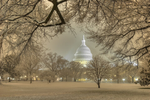
WASHINGTON — The week began with sleet, freezing rain and snow around the D.C. area, resulting in school closings and delays as well as messy morning traffic on Monday. Tuesday will begin with more misery, but the worst of it will be confined to parts north and west of the District.
- Listen to WTOP online and on the radio at 103.5 FM or 107.7 FM.
- Current traffic conditions
- Weather forecast
- Closings and delays
- Sign up for WTOP alerts
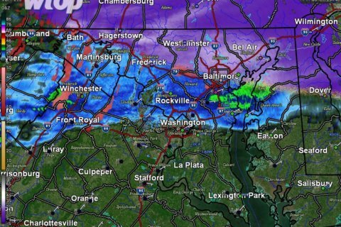
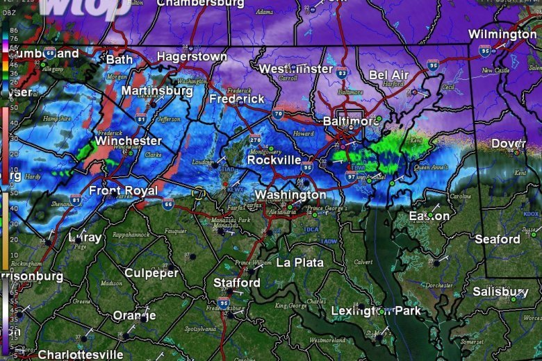
A winter weather advisory is in effect for parts of the area until 10 a.m. Tuesday. This includes Montgomery County in Maryland and Loudoun, Fauquier and Rappahannock counties in Virginia.
A Weather Storm Warning has been expanded to include all counties along the border with PA including Northern Baltimore County and Northwestern Harford County until 10am Tuesday. Check https://t.co/ZOlvESgJ2H for additional information. pic.twitter.com/rrEdmFymIi
— NWS DC/Baltimore (@NWS_BaltWash) February 12, 2019
Minor accumulations are expected in northern Maryland this evening, said Storm Team4 Meterologist Matt Ritter. The rest of the area can expect rain, drizzle and fog, with the potential of a refreeze.
So be careful out there.
“I am most concerned for slick spots tomorrow morning leading to some delays and possibly cancellations with a mix of snow, sleet and freezing rain in the forecast,” said Storm Team4 Meteorologist Amelia Draper.
Toward the late morning hours, temperatures will warm, and any mix will change over to rain, Draper said. That rain could get heavier into the evening commute, too, and cause flooding in low-lying areas.
The forecast
MONDAY NIGHT: Wintry mix, especially around the Mason-Dixon Line and Interstate 81 corridor, where a few slushy inches of snow are possible, then some ice accumulation from freezing rain. Mainly just rain in D.C. and to the south and east.
Lows: Low to mid-30s.TUESDAY: Wintry mix early, mainly north and west of D.C. Freezing rain switches to all rain around 10 a.m. Some heavy rain possible late in the day; flooding possible.
High: Around 40.WEDNESDAY: Partly sunny and blustery.
High: 40s; wind chills in 20s and 30s.THURSDAY: Sunny and warmer.
High: Low 50s.FRIDAY: Cloudy with a chance of rain.
High: Mid-50s to near 60.
Messy start to the week
Federal offices opened two hours late Monday, and federal employees had the option for unscheduled leave or telework. Several school districts were also closed or opening late.
Sunday evening’s light snow transitioned into a wintry mix of rain and sleet around midnight and some freezing rain on Monday morning. Road crews were ready for it.
Earlier, Maryland Department of Transportation spokesman Charlie Gischlar said the major roadways were treated and that crews and contractors would be out to keep the roads clear while the snow and ice accumulates. (MDOT now offers an app that allows residents to track where plows have been in order to find the most well treated roads.)
Virginia Department of Transportation spokeswoman Ellen Kamilakis told WTOP that pre-treatment began Saturday. The goal, Kamilakis explained, was to buy crews time once the rain starts before ice begins to bond on the pavement.
“We’re always concerned about bridges, ramps and overpasses since they freeze a lot quicker,” she said. “We really don’t gamble with that kind of thing, so we’ll be out in force to make the commute as safe as possible.”
Get the full forecast on the WTOP.com weather page.
WTOP’s Jack Pointer contributed to this report.