WASHINGTON — If you didn’t get your fix of snow Thursday overnight, there’s another chance knocking on our doorstep. A storm system moving out of the south is bringing several inches of snow to some of our area Saturday.
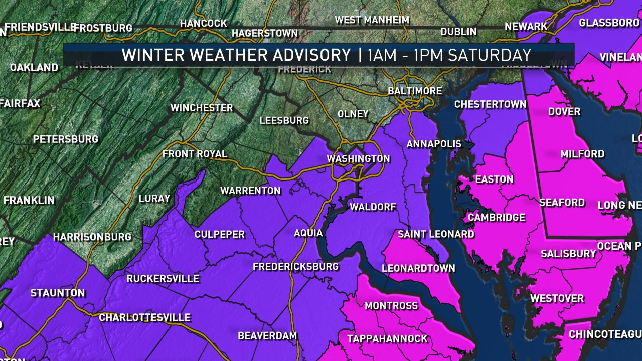
A Winter Weather Advisory is in effect from 1 a.m. to 1 p.m Saturday for D.C., Arlington, Alexandria, Fairfax, Prince William, southern Fauquier, Prince George’s, Anne Arundel, Charles, Stafford, King George, southeastern and central Montgomery and southeastern and central Howard Counties.
There’s a Winter Storm Warning in effect for Calvert County, Maryland; St. Mary’s County, Maryland, and parts of Northern Neck from 1 a.m. to 7 p.m. Saturday.
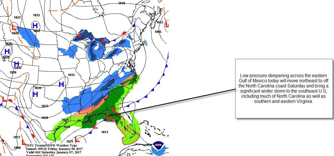
An area of low pressure moved off the coast of the Carolinas Saturday morning. Due to the south/southeast track of this area, low and cold air from the north will be pulled into the mid-Atlantic, and it also will bring moisture with it from the Gulf of Mexico. Temperatures will remain in the upper 20s to the lower 30s for daytime highs on Saturday.
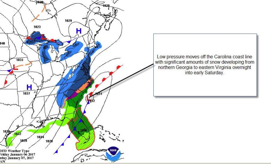
Considering the track of this, low areas to the north and west of D.C. will actually remain dry. Those areas could even see a few peeks of sunshine through the day. But the D.C. and Baltimore area and areas south and east have the best chance to see some flakes fly, especially the farther south you travel.
We are watching the track of this system. If the system nudges north slightly, the snow totals could be different. If it heads to the south and east, then it will take the snow with it, and totals will be on the lighter side for the southeastern region. Either way, there will be a sharp cut-off for those who see snow and those who do not, mainly due to dry air moving in from the north and west.
Snow totals
Again if the track shifts, these totals will shift, as well.
Locations east of Interstate 95 could see 1 to 3 inches of snow. That includes portions of Fairfax, Prince William, Spotsylvania, Prince George’s and Anne Arundel counties. The D.C. metro area could see a dusting to 2 inches.
The “sweet spot” will be St. Mary’s County, Maryland, where there’s a Winter Storm Warning. Locations in this county could receive 3 inches or more especially by the southern tip of St. Mary’s County, including Point Lookout, which could receive some of the highest amounts.
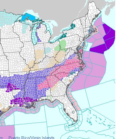
If you are traveling, several inches of snow are expected around Richmond, through southern Virginia and into the Carolinas. Winter Storm Warnings extend all the way to Alabama.
Timing
Snow moved into the region after midnight Friday and before daybreak. It will continue through the mid-afternoon and most likely will be out of the region after 3 or 4 p.m. Snow could linger for Southern Maryland and into the Eastern Shore through the first part of the evening, but most of the snow will have left the region.
Aftermath
Winds will pick up as the snow leaves the area. In fact, we could have gusts up to 20 mph through Saturday afternoon and into the evening. Wind chills will only be in the teens during the afternoon and fall into the single digits for Saturday night into Sunday morning. It will be quite blustery on Sunday, with wind gusts up to 30 mph possible. Wind chills will be in the teens for much of the day on Sunday; however, even with sunshine expected Sunday, it will be quite frigid.
Be sure not to leave the pets outside for an extended amount of time over the weekend. It will be dangerously cold all day Sunday.
Eventually, we warm up. Temperatures are expected to top out in the 50s by next Wednesday and Thursday. Warmer air is headed our way.