WASHINGTON — We are going to get some rain, but not from Hurricane Joaquin.
We are still watching the flooding threat as we continue through this Friday and Saturday. An area of low pressure in the upper levels of the atmosphere is hanging out in the Deep South, nudging a stalled frontal boundary off the eastern seaboard back inland. A surface low has also developed along the front. All this means rain for us in the WTOP region, that unfortunately will continue to intensify through the day Friday. We could have anywhere from 1 to 3 inches, with some locally higher amounts (on top of what we received Tuesday night).
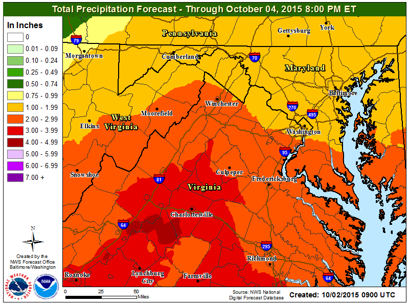
The heaviest rain will fall Friday afternoon through early Saturday morning. Again, it is not going to take much to get some flooding through the region, especially as the rain picks up in intensity Friday night.
Flash Flood Watch in effect through early Sat morning. Heaviest rain this aft. — early Sat. AM @wtop @nbcwashington pic.twitter.com/goaQN01TZB
— Lauryn Ricketts (@laurynricketts) October 2, 2015
So plan ahead for some flooding concerns with heavy rain if you are out and about Friday night into early Saturday morning. It will be a good idea to move valuables off the basement floor and check sump pumps and generators — hopefully, your gutters and downspouts are already clear in anticipation of some really heavy rain.
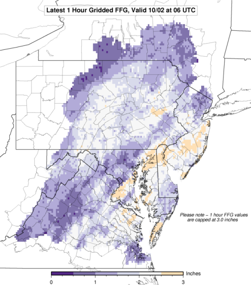
Conditions will deteriorate quickly if we see just around an inch of rain in an hour for some of our region. The graphic above shows the flash flooding possibility, or how much rain needs to fall in one hour to start flooding. Again the heaviest rain will fall from 3 or 4 p.m. Friday afternoon through the late overnight hours leading into Saturday. We will have to worry about the winds. A strong area of high pressure over Canada will help to create some pretty strong winds out of the northeast for much of the mid-Atlantic. Winds could gust anywhere from 30 to 40 mph, with the higher gusts along the Bay and other shorelines, and the ridgetops. Rain will begin to taper off to just showers through midday Saturday. Winds will still be around, though; in fact, strong winds will be with us through the weekend! If you are headed to Howard’s homecoming, college football games at Maryland, Virginia Tech, Penn State or the Naval Academy, or any weddings, know that it will be cool and very windy, with some scattered showers.
Very Windy for #CollegeFootball with scattered showers (heaviest rain over in AM) #Hokies #terps #howardhomecoming pic.twitter.com/FCIDIge0r1 — Lauryn Ricketts (@laurynricketts) October 2, 2015
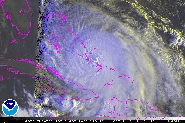
Hurricane Joaquin
The track has continued to shift off the eastern seaboard, so we’re looking at minimal impacts here in the mid-Atlantic.
Northeasterly turn but #Joaquin staying off the coast. Runs paralell to NC beaches Sunday/Mon @WTOP @nbcwashington pic.twitter.com/5hXoX8u42P
— Lauryn Ricketts (@laurynricketts) October 2, 2015
As of 5 a.m., Joaquin is still a very impressive hurricane as it continues to swirl through the Bahamas, just crawling to the northwest at 3 mph. Sustained winds are up to 130 mph with a pressure of 935mb. It will start to accelerate Friday and move away to the north with a gradual turn to the northeast Friday night through Saturday. Hurricane-force winds extend out of Joaquin about 50 miles from the center, with tropical storm-force winds moving out about 205 miles from the center.
Although the track is fairly far off the East Coast, parts of the southeastern U.S. are already experiencing some pretty high seas. This will only continue to trend up the east coast and into the mid-Atlantic through the weekend. Expect high surf, rip currents, some coastal flooding and beach erosion during the weekend while Joaquin spins away from the East Coast.
Relief is in sight by the time we get into Monday. While we may still have a little bit of a wind, we will start to see some sunshine with high pressure building in. Sunshine is expected, with temperatures returning to the 70s for much of next week!