The new model run is here. The new model run is HERE!!! Extra, extra, read all about it! Snow chances for DC are dropping. The last run was still giving DC about .5" but the new one... ZILCH! The trend is NOT our friend. Higher chances remain South. pic.twitter.com/nvqnaxw4MF
— Chuck Bell (@ChuckBell4) April 6, 2018
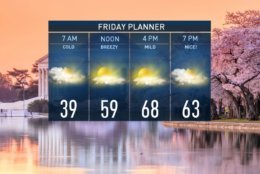
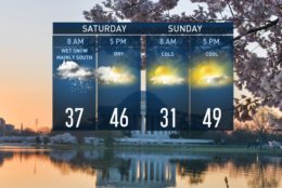
Rejoice! It's Friday, cherry blossoms are in peak bloom AND we'll warm to near 70º today. Enjoy because 40s and rain/snow greet us tomorrow morning. pic.twitter.com/WG2AxcY9E1
— Amelia Draper (@amelia_draper) April 6, 2018
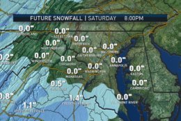
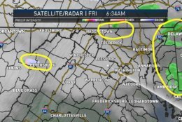
Still watching the track of snow for Saturday. . . looks mainly South of the DC Metro area right now. Since it will be the Northern edge of this system, it still has time to shift a bit North or South. Wake up with us! @nbcwashington pic.twitter.com/c1s4muYbWy
— Sheena Parveen (@SheenaParveen) April 6, 2018
Cloudy skies for all but sprinkles and random snowflakes for a tiny few this morning. On the chilly side too. Temps in the low/mid 40s this morning. An increasing Southwest wind will bring breaks of sunshine and much warmer air by this aftn. High: 68° pic.twitter.com/8IgFQCLnIc
— Chuck Bell (@ChuckBell4) April 6, 2018

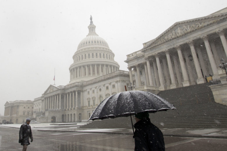
WASHINGTON — April’s showers may well contain a snowy mix Saturday but it’s likely they will have a minor impact and be confined to areas south of the D.C. region, according to meteorologists.
“Today’s warmth is yet another limiting factor in snow chances for Saturday,” said Storm Team4 Meteorologist Chuck Bell.
“Light rain will move in after midnight. It will start as rain with temperatures in the mid-40s until nearly daybreak. As the rain increases in intensity early Saturday morning it will help to cool the atmosphere,” Bell said.
“Saturday almost all clouds all day long, pockets of light rain and possibly a few wet snowflakes mixed in, better chances of seeing a slight accumulation of snow, an inch or less down toward Fredericksburg on the south side of the area, as opposed to north of the city,” he added.
Storm Team4 Meteorologist Sheena Parveen is tracking the potential snowfall. She said it looks as though areas south of D.C. could be affected but that the forecast might change during the day Friday.
The biggest “threat” of the weekend will be the odds of a hard freeze Sunday morning. Cherry Blossoms do not fair well below freezing and most areas will be in the upper 20s to around 30 Sunday morning, according to Bell.
Sunday will be sunny and chilly.
Current conditions
The D.C. area has seen snow in April before but it is relatively rare.
Measurable snow has only been recorded three times in the last 50 years at Reagan National Airport, most recently on April 7, 2007. The area also had previous bouts of April snow in 1990 and 1972.
The latest major snowfall of the year, meaning 4 inches or more, for the D.C. region happened during the April Fools’ Day Storm in 1924.
D.C. got 5 inches of snow. Baltimore got more than 9 inches.
The National Weather Service said the latest snow has fallen in the year for the D.C. area was on April 28, 1898 when half an inch fell in D.C. and .1 inches fell in Baltimore.
The latest snow was seen in D.C. was on May 10, 1906 when a trace fell.