


Dave Dildine, wtop.com
Megan Cloherty, wtop.com
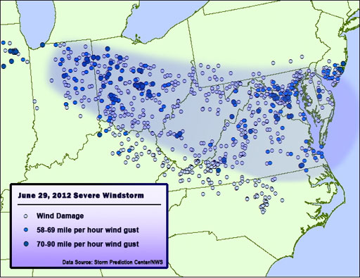
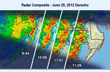
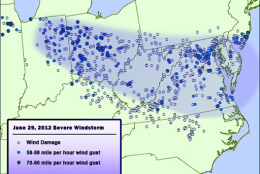
WASHINGTON – The ferocious storm that blew through the Washington-area Friday night is a weather system known as a derecho.
It is not only an unusual weather event for the region, but the circumstances surrounding the storm changed its pattern characteristics, according to ABC 7 Meterologist Mike Stinneford.
Derecho is a Spanish word that means “straight.” It is in reference to the storm’s powerful straight-line winds.
Derechos typically form along the top of a hot air mass and can move an average of 70 miles per hour. That wind speed is normally associated with a Category 1 hurricane.
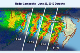
WTOP Traffic Reporter Dave Dildine is also a weather research analyst. He compiled this chronology of the derecho’s movements Friday.
Timeline of Friday’s derecho forecast
8:53 a.m. eastern time
The Storm Prediction Center places the Mid-Atlantic, including the Washington, D.C metro area, under a slight risk for severe weather. They note “considerable variability in storm evolution” but point to the possibility of “damaging winds spreading south-eastward” through the evening.
10:35 a.m.
The National Weather Service in Sterling, Va., introduces increased chances for thunderstorms for the Washington area, stating that they “expect storms to continue to roll east