WASHINGTON — Are you ready for more of a winter warm-up? Winter doesn’t begin until Tuesday, Dec. 22, but until then it will feel more like late spring!. Temperatures will be running about 20 degrees above the average this weekend, so make some plans to get outdoors. Usually, by this time of year, we already have had the heat working overtime.
It’s not too unusual to have warm temperatures in December. Over the past five years, five days in December reached 70 degrees or warmer at DCA; there were 19 days with temperatures at 60 degrees or above. Meanwhile, at BWI, four December have hit 70 degrees or above; there were 16 days at 60. At Dulles, four days reached 70 or above; 15 days reached 60 or above.
So we’ve seen some warm days in December. But these past few weeks have been exceptionally warm: Last month, our average temperature at DCA was 53.7 degrees, making it the sixth-warmest on record.
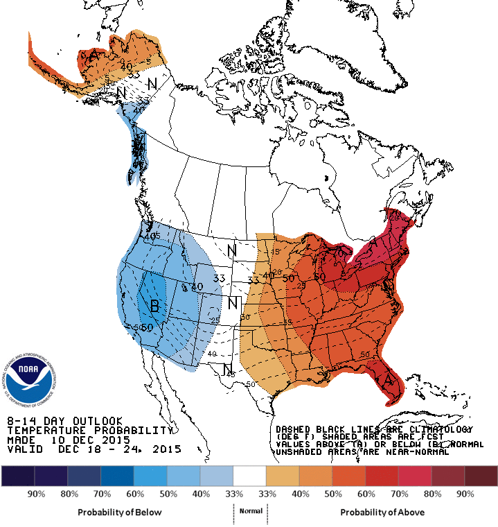
It looks as if the region will continue with warm temperatures as we head through December, as cold air is locked to the north. Some models suggest that the cold air will try to spill south and east and make a run at us right before Christmas, but we will have to continue to watch that trend. Until then, the Climate Prediction Center forecasts that temperatures will be above normal for much of the eastern half of the United States.
As for this weekend and beyond, enjoy very warm temperatures. Forecast highs are near 70 for Saturday through Monday. That means we could challenge some records for this weekend.
It is a #Fabulous4Friday with warming temps all weekend! Could challenge some records too! @wtop @nbcwashington pic.twitter.com/mxcW9WEq1I
— Lauryn Ricketts (@laurynricketts) December 11, 2015
This will be a great weekend to get outside and maybe finish decorating, or enjoy a late-season farm market. Just know that each morning will feature a little fog, with temperatures warming in the afternoon. Sunday looks a lot cloudier than Saturday, but the rain doesn’t arrive until Monday, so we will stay dry through the weekend! There is no sign of cold air infiltrating the East Coast; we’ll stay above normal for much of the week, despite frontal passages on Monday and again on Thursday.