The severe windstorm that roared southeast from
the Great Lakes into the Mid-Atlantic in June
was an extreme weather event for the Washington,
D.C. metro area. The storm system left extensive
tree damage in its wake and more than one
million people were without power.
This graphic shows the National Weather Service Weather Radar of the June 29, 2012 derecho compared with the June 4, 2008 derecho. The 2012 complex of storms and its swath of wind damage was much larger than the 2008 event. (WTOP/Dave Dildine)
WTOP/Dave Dildine
National Weather Service Weather Radar showing
the June 4, 2008 derecho at 2:37 p.m. as it
entered the western suburbs. The swirling
"bookend" vortex west of Frederick, Md. was
responsible for producing localized winds in
excess of 100 mph. (WTOP/Dave Dildine)
WTOP/Dave Dildine
National Weather Service Weather Radar showing the
June 4, 2008 derecho at 3:14 p.m. as it entered
the metro area. Winds at National Airport gusted
to 59 mph as the leading edge of the storms moved
through. (WTOP/Dave Dildine)
WTOP/Dave Dildine
259503
National Weather Service Weather Radar showing the
June 29, 2012 derecho at 10:48 p.m. as it entered
the metro area. The 2012 complex of storms and its
swath of wind damage was much larger than the 2008
derecho event. Widespread damaging winds in excess
of 70 mph raked across the entire region.
(WTOP/Dave Dildine)
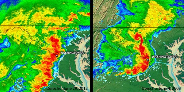
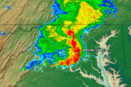
WASHINGTON – The severe windstorm that roared southeast from the Great Lakes into the Mid-Atlantic in June was an extreme weather event for the Washington, D.C. metro area. The storm system left extensive tree damage in its wake and more than one million people were without power.
The storm complex was a “derecho.” Although the intensity of the June storms was exceptional, it’s happened before.
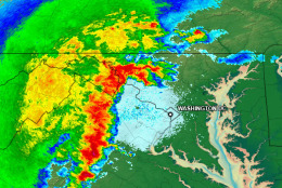
A derecho of similar speed and intensity struck the region the afternoon of June 4, 2008. Like June 2012’s windstorm, the